From Map Margin to Meeting Place: Reading an Old Parish Map
An old parish map can reveal how a place was meant to be understood. Its title, key, scale and annotations often explain more than a quick search for familiar landmarks.
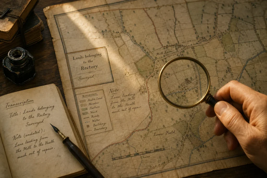
A title such as “Map of the Parish Lands” changes how you should read the sheet: it signals that the map may be organised around ownership or administration, not a visitor’s route through the village. Before trying to locate a vanished meeting house, read the information printed or written around the map itself. Those margins can tell you what the map records, which details belong to a later hand, and where its picture of the parish begins and ends.
The title reveals what the map was made to show
Start with the full title, not just the place name. A map prepared to record glebe land, estates or parish boundaries may give those subjects prominence while omitting minor paths and cottages. A map made to show a route or a proposed change may give roads unusual emphasis. The title is a clue to the map’s purpose, not a complete account of it, so read it alongside the key and any explanatory notes.
Notice wording such as “surveyed”, “drawn” or “for the use of”. A date beside one of these terms may refer to a particular stage in the map’s making. If the sheet also bears a publication date or a handwritten date, record each separately. They can refer to different moments, and a later annotation need not describe the same landscape shown in the original drawing.
Imagine you have a parish sheet titled “Lands belonging to the Rectory”, with an undated ink note beside a lane. You transcribe the title and note separately, then compare the handwriting and ink with the printed map rather than assuming they were added together. The result is a cautious reading: the sheet centres on rectory property, while the lane note may describe a later change whose date remains unknown.
The key sets limits on what symbols can mean
Read the legend before assigning a meaning to a mark. A coloured wash may distinguish land use or ownership; a line could represent a boundary, road or watercourse, depending on the map’s own conventions. If a symbol has no key, compare it with repeated examples and with the words printed nearby. Similarity can support a reading, but it does not turn an unexplained mark into a definite building type.
Keep a transcription of the key close to your notes. If the original labels a mark “house”, preserve that wording instead of silently replacing it with “farmhouse” or “meeting room”. When a symbol’s meaning remains open, describe its appearance and position: for instance, “small filled rectangle beside the lane”. That gives another reader something observable to check without implying more than the map says.
The scale and sheet edges define what you can claim
A scale bar helps you judge distance only if the image has not been stretched, cropped or reproduced at an unknown size. Check whether the bar is visible in the copy you are using and whether the map’s edges appear complete. A scan that cuts off the title block or a strip of margin may remove the very information needed to interpret a boundary or date.
Look at the border as part of the record. A parish boundary drawn at the edge may indicate that the map focuses on the parish interior; a neighbouring place named just beyond it may offer context, but not necessarily equal detail. Do not treat blank space outside the border as evidence that no settlement or route existed there. It may simply fall beyond the map’s subject.
If a digital image is the only copy available, note that limitation. Avoid giving a precise distance from a resized image, and seek a fuller reproduction or catalogue description when the scale or missing margin affects your interpretation.
Annotations may belong to a different moment
Handwritten names, coloured lines and pencil marks can be later additions. Look for differences in ink, lettering, placement and whether an annotation crosses the printed design. These features can suggest separate layers, but they do not establish who made an addition or when. Describe what you can see before proposing a date or purpose.
Keep the map’s original marks and later notes distinct in your transcription. If an annotation appears to rename a lane, record the printed name and handwritten name separately, then note that the relationship is uncertain unless another source clarifies it. This preserves useful detail without making a later reader’s note part of the original survey.
Use each observation to make a clear decision
- Check the title and any statement of purpose. If it names land or property as its subject, treat ownership details as central and avoid assuming that minor routes are complete; if the title instead describes a route or public work, examine the route marks first.
- Check every date and the words beside it. If a date is explicitly tied to a survey, record it as the survey date; if it appears beside publication or handwriting, keep it in a separate note until its role is clear.
- Check the legend for the symbol you want to identify. If the key names it, use that term; if no explanation appears, describe the mark’s shape and position rather than assigning it a building type.
- Check whether the scale bar and full sheet are visible. If both are present and the image looks undistorted, use the scale cautiously; if either is missing or the sheet is stretched, avoid precise distance claims and seek a fuller copy.
- Check whether handwriting differs from the printed layer. If it is visibly separate, transcribe it as an annotation; if its status is unclear, mark it as uncertain rather than blending it into the map’s original labels.
- Check what lies at the map’s border. If the parish edge or crop cuts off a feature, describe the map’s coverage as limited; if neighbouring labels are visible, use them as context without assuming the sheet gives that area equal detail.
Describe the evidence before naming a vanished place
For a missing chapel, school or meeting house, first record exactly what the map shows: the symbol, its label, its relation to a lane or boundary, and any relevant key entry. Then state what you infer from those details and what remains unresolved. “A building mark beside the lane, labelled ‘school’” is firmer than “the old school stood here” if the map’s date, symbol or location is uncertain.
This distinction is especially useful when you compare the map with parish records or a modern plan. If another source suggests a different site, your notes can be revised without losing the original observation. A good reading leaves the next researcher not only a proposed answer, but also a clear account of what the sheet itself actually says.
Nearby stories
The Lane Beneath the Field: Following a Lost Boundary
A hedge, a hollow and a field name can preserve different parts of a landscape’s past.…
The Joint Between Two Eras: Brick Bonds as Building Clues
Read brick patterns as evidence of how a wall was put together, then compare them with…